


BULLETIN
Tropical Storm Fred Advisory Number 8
NWS National Hurricane Center Miami FL AL062021
1100 AM AST Wed Aug 11 2021
…CENTER OF FRED CLOSE TO THE SOUTHERN COAST OF THE DOMINICAN
REPUBLIC…
…TROPICAL STORM WATCH ISSUED FOR PORTIONS OF CUBA…
SUMMARY OF 1100 AM AST…1500 UTC…INFORMATION
———————————————–
LOCATION…18.2N 69.7W
ABOUT 25 MI…40 KM SSE OF SANTO DOMINGO DOMINICAN REPUBLIC
ABOUT 245 MI…395 KM SSE OF GRAND TURK ISLAND
MAXIMUM SUSTAINED WINDS…45 MPH…75 KM/H
PRESENT MOVEMENT…WNW OR 290 DEGREES AT 16 MPH…26 KM/H
MINIMUM CENTRAL PRESSURE…1006 MB…29.71 INCHES
WATCHES AND WARNINGS
——————–
CHANGES WITH THIS ADVISORY:
The Government of Cuba has issued a Tropical Storm Watch for the
provinces of Ciego de Avila, Camaguey, Las Tunas, Holguin, Granma,
Santiago de Cuba, and Guantanamo.
SUMMARY OF WATCHES AND WARNINGS IN EFFECT:
A Tropical Storm Warning is in effect for…
* Dominican Republic on the south coast from Punta Palenque
eastward and on the north coast from the Dominican
Republic/Haiti border eastward
A Tropical Storm Watch is in effect for…
* Haiti from the northern border with the Dominican Republic to
Gonaives
* Turks and Caicos Islands
* Southeastern Bahamas
* The Cuban provinces of Ciego de Avila, Camaguey, Las Tunas,
Holguin, Granma, Santiago de Cuba, and Guantanamo
A Tropical Storm Warning means that tropical storm conditions are
expected somewhere within the warning area, in this case within the
next 12 hours.
A Tropical Storm Watch means that tropical storm conditions are
possible within the watch area.
Interests elsewhere in Haiti, the Bahamas, Cuba, and the southern
Florida Peninsula and the Florida keys should monitor the progress
of Fred.
For storm information specific to your area, please monitor
products issued by your national meteorological service.
DISCUSSION AND OUTLOOK
———————-
At 1100 AM AST (1500 UTC), the center of Tropical Storm Fred was
located near latitude 18.2 North, longitude 69.7 West. Fred is
moving toward the west-northwest near 16 mph (26 km/h), and a
general west-northwestward motion with a decrease in forward speed
is expected to continue for the next few days. On the forecast
track, the center of Fred is expected to be near or over Hispaniola
this afternoon and evening, move near the Turks and Caicos Islands
and the southeastern Bahamas on Thursday, and move near or north of
the northern coast of central Cuba on Friday.
Maximum sustained winds are now near 45 mph (75 km/h) with higher
gusts. Weakening is expected later today and tonight as the center
of Fred crosses Hispaniola. Slow re-intensification is expected
beginning Thursday night.
Tropical-storm-force winds extend outward up to 60 miles (95 km)
mainly to the northeast of the center. La Romana, Dominican
Republic, recently reported sustained winds of 35 mph (56 km/h).
The estimated minimum central pressure is 1006 mb (29.71 inches).
HAZARDS AFFECTING LAND
———————-
Key messages for Tropical Storm Fred can be found in the Tropical
Cyclone Discussion under AWIPS header MIATCDAT1, WMO header
WTNT41 KNHC and on the web at
www.hurricanes.gov/graphics_at1.shtml?key_messages.
RAINFALL: Tropical Storm Fred is expected to produce the following
rainfall amounts:
Across the Dominican Republic…3 to 5 inches, with isolated maximum
totals of 8 inches. Heavy rainfall could lead to flash, urban, and
small stream flooding, along with possible rapid river rises and the
potential for mudslides.
Over Haiti, the Turks and Caicos, the eastern Bahamas, and Cuba…1
to 3 inches with isolated maximum totals of 5 inches.
Across the western Bahamas…3 to 5 inches, with isolated maximum
totals of 8 inches.
By Friday into early next week, heavy rainfall associated with Fred
will impact Florida and parts of the Southeast. Through Monday, 3 to
5 inches of rain is anticipated across the Keys and southern Florida
peninsula, with isolated maximum totals of 8 inches. Heavy rainfall
could lead to flash, urban, and small stream flooding, along with
possible rapid river rises.
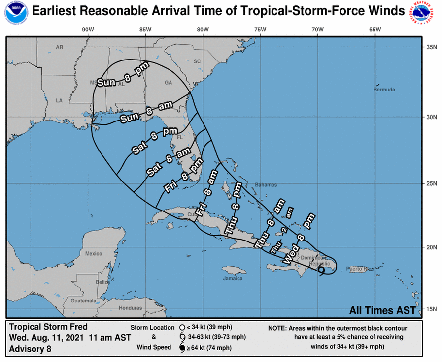
WIND: Tropical storm conditions are spreading across portions of
the warning area in the Dominican Republic, and these conditions
should continue today. Tropical storm conditions are possible along
the northern coast of Haiti, the Turks and Caicos, and the
southeastern Bahamas beginning late today. Tropical storm
conditions are possible in Cuba beginning tonight.
SURF: Swells generated by Tropical Storm Fred are expected to
continue across the U.S. Virgin Islands and Puerto Rico and reach
portions of Hispaniola today, where they could cause
life-threatening surf and rip current conditions. Please consult
products from your local weather office.
