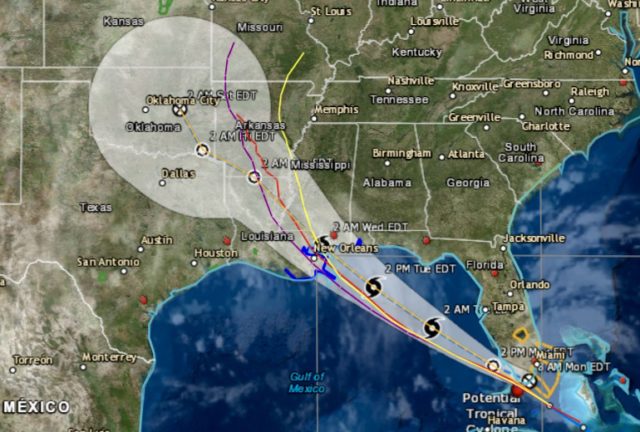
National Weather Service Mobile AL AL072018
512 AM CDT Mon Sep 3 2018
This product covers portions of southwest Alabama…northwest Florida...south central Alabama…and inland southeast Mississippi.
**TROPICAL STORM CONDITIONS AND HEAVY RAINFALL EXPECTED TO IMPACT
PORTIONS OF THE CENTRAL GULF COAST TUESDAY INTO WEDNESDAY**
NEW INFORMATION
—————
* CHANGES TO WATCHES AND WARNINGS:
– The Tropical Storm Watch has been upgraded to a Tropical Storm
Warning for Baldwin Central, Baldwin Coastal, Mobile Central,
and Mobile Coastal
* CURRENT WATCHES AND WARNINGS:
– A Tropical Storm Warning is in effect for Baldwin Central,
Baldwin Coastal, Mobile Central, and Mobile Coastal
* STORM INFORMATION:
– About 640 miles southeast of Mobile AL or about 590 miles
southeast of Pensacola FL
– 24.5N 80.2W
– Storm Intensity 30 mph
– Movement West-northwest or 300 degrees at 16 mph
SITUATION OVERVIEW
——————
A tropical disturbance approaching the Straits of Florida early this
morning is forecast to move into the southeast Gulf of Mexico later
today. The system is expected to reach the central Gulf coast by late
Tuesday or Tuesday night. This system will have the potential to bring
significant rainfall amounts and flash flooding to the area, mainly across portions of inland southeast Mississippi, southwest Alabama, and the western Florida panhandle. Tropical storm force winds and coastal flooding impacts are also possible.
POTENTIAL IMPACTS
—————–
* FLOODING RAIN:
Protect against locally hazardous rainfall flooding having possible
limited impacts across portions of southwest Alabama…northwest
Florida…south central Alabama…and southeast Mississippi.
Potential impacts include:
– Localized rainfall flooding may prompt a few evacuations.
– Rivers and tributaries may quickly rise with swifter currents.
Small streams, creeks, canals, and ditches may become swollen
and overflow in spots.
– Flood waters can enter a few structures, especially in usually
vulnerable spots. A few places where rapid ponding of water
occurs at underpasses, low-lying spots, and poor drainage
areas. Several storm drains and retention ponds become
near-full and begin to overflow. Some brief road and bridge
closures.
* SURGE:
Protect against locally hazardous surge having possible limited
impacts across coastal Alabama and coastal portions of the western
Florida panhandle. Potential impacts in this area include:
– Localized inundation with storm surge flooding mainly along
immediate shorelines and in low-lying spots, or in areas
farther inland near where higher surge waters move ashore.
– Sections of near-shore roads and parking lots become overspread with surge water. Driving conditions dangerous in places where surge water covers the road.
– Moderate beach erosion. Heavy surf also breaching dunes, mainly in usually vulnerable locations. Strong rip currents.
– Minor to locally moderate damage to marinas, docks, boardwalks and piers. A few small craft broken away from moorings. Elsewhere across portions of southwest Alabama…northwest Florida…south central Alabama…and inland southeast Mississippi., little to no impact is anticipated.
* WIND:
Protect against dangerous wind having possible significant impacts
across coastal portions of southwest Alabama and possibly into lower
portions of southeast Mississippi. Potential impacts in this area
include:
– Some damage to roofing and siding materials, along with damage
to porches, awnings, carports, and sheds. A few buildings
experiencing window, door, and garage door failures. Mobile
homes damaged, especially if unanchored. Unsecured lightweight
objects become dangerous projectiles.
– Several large trees snapped or uprooted, but with greater
numbers in places where trees are shallow rooted. Several
fences and roadway signs blown over.
– Some roads impassable from large debris, and more within urban or heavily wooded places.
– Scattered power and communications outages, but more prevalent in areas with above ground lines.
Also, protect against hazardous wind having possible limited impacts
across the rest of inland southeast Mississippi, southwest and south
central Alabama and the northwest Florida panhandle.
* TORNADOES:
Protect against a tornado event having possible limited impacts across across extreme southeast Mississippi, extreme southwest Alabama and a portion of the western Florida panhandle. Potential impacts include:
– The occurrence of isolated tornadoes can hinder the execution
of emergency plans during tropical events.
– A few places may experience tornado damage, along with power
and communications disruptions.
– Locations could realize roofs peeled off buildings, chimneys
toppled, mobile homes pushed off foundations or overturned,
large tree tops and branches snapped off, shallow-rooted trees
knocked over, moving vehicles blown off roads, and small boats
pulled from moorings.
Elsewhere across portions of southwest Alabama…northwest
Florida…south central Alabama…and inland southeast Mississippi.,
little to no impact is anticipated.
PRECAUTIONARY/PREPAREDNESS ACTIONS
———————————-
* EVACUATIONS:
Listen to local official for recommended preparedness actions,
including possible evacuation. If ordered to evacuate, do so
immediately.
* OTHER PREPAREDNESS INFORMATION:
Now is the time to complete all preparations to protect life and
property in accordance with your emergency plan. Ensure you are in a safe location before the onset of strong winds or possible flooding.
Closely monitor weather.gov, NOAA Weather radio or local news outlets
for official storm information. Be ready to adapt to possible changes
to the forecast. Ensure you have multiple ways to receive weather


