


Navarre Newspaper will bring you complete coverage of Alberto as it lands on Navarre Beach. Our reporter and video camera will be located on Navarre beach to report the approach, landing and aftermath of Alberto.

UPDATE at 9 am.
Larger waves are at Navarre beach as of 9 am.


Below is the latest bulletin from the National Hurricane Center in Miami ,FL.
WTNT31 KNHC 271149
TCPAT1
BULLETIN
Subtropical Storm Alberto Intermediate Advisory Number 8A
NWS National Hurricane Center Miami FL AL012018
800 AM EDT Sun May 27 2018
…SLIGHTLY STRONGER ALBERTO MOVING A LITTLE FASTER NORTHWARD OVER
THE EASTERN GULF OF MEXICO…
SUMMARY OF 800 AM EDT…1200 UTC…INFORMATION
———————————————-
LOCATION…26.3N 84.4W
ABOUT 165 MI…265 KM SW OF TAMPA FLORIDA
ABOUT 240 MI…385 KM S OF APALACHICOLA FLORIDA
MAXIMUM SUSTAINED WINDS…45 MPH…75 KM/H
PRESENT MOVEMENT…N OR 010 DEGREES AT 15 MPH…24 KM/H
MINIMUM CENTRAL PRESSURE…997 MB…29.44 INCHES
WATCHES AND WARNINGS
——————–
CHANGES WITH THIS ADVISORY:
None
SUMMARY OF WATCHES AND WARNINGS IN EFFECT:
A Storm Surge Watch is in effect for…
* Crystal River to the Mississippi/Alabama border
A Tropical Storm Warning is in effect for…
* Dry Tortugas
* Bonita Beach to the Mississippi/Alabama border
A Tropical Storm Watch is in effect for…
* Mississippi/Alabama border to the Mouth of the Pearl River
A Storm Surge Watch means there is a possibility of life-
threatening inundation, from rising water moving inland from the
coastline, in the indicated locations in this case during the next
36 hours. For a depiction of areas at risk, please see the National
Weather Service Storm Surge Watch/Warning Graphic, available at
A Tropical Storm Warning means that tropical storm conditions are
expected somewhere within the warning area.
A Tropical Storm Watch means that tropical storm conditions are
possible somewhere within the watch area.
For storm information specific to your area in the United
States, including possible inland watches and warnings, please
monitor products issued by your local National Weather Service
forecast office. For storm information specific to your area outside
the United States, please monitor products issued by your national
meteorological service.
DISCUSSION AND OUTLOOK
———————-
At 800 AM EDT (1200 UTC), the center of Subtropical Storm Alberto
was located near latitude 26.3 North, longitude 84.4 West. The
storm is moving toward the north near 15 mph (24 km/h). A turn
toward the north-northwest at a slower forward speed is forecast
tonight. A north-northwestward to northward motion is expected
Tuesday through early Wednesday. On the forecast track, the center
of Alberto will cross the eastern and northern Gulf of Mexico today
and approach the northern Gulf Coast in the warning area tonight or
Monday. Heavy rainfall and tropical storm conditions will likely
reach the northern Gulf Coast well before the arrival of the center
of Alberto. Alberto is expected to move northward into the
Tennessee Valley on Tuesday and Wednesday.
Maximum sustained winds have increased to near 45 mph (75 km/h) with
higher gusts. Gradual strengthening is forecast until the system
reaches the northern Gulf Coast. Steady weakening is expected after
Alberto makes landfall, and it is forecast to become a tropical
depression by Monday night or Tuesday.
Winds of 40 mph extend outward up to 150 miles (240 km) mainly to
the east of the center.
The estimated minimum central pressure based on data from an Air
Force Reserve reconnaissance aircraft data is 997 mb (29.44 inches).
HAZARDS AFFECTING LAND
———————-
RAINFALL: Alberto is expected to produce the following rain
accumulations through Tuesday:
Central Cuba…Additional 5 to 10 inches, isolated storm totals of
20 inches.
The Florida panhandle into eastern Alabama and western Georgia…4
to 8 inches, isolated 12 inches.
The Florida Keys and south Florida…Additional 3 to 6 inches,
isolated storm totals of 10 inches.
Rest of the Florida peninsula…1 to 4 inches.
Rest of the southeast U.S. from Tennessee to the Carolinas…2 to 6
inches.
Rains in Cuba could produce life-threatening flash floods and
mudslides. Flooding and flash flooding are possible in the southeast
United States, including Florida.
WIND: Tropical storm conditions are occurring in the Dry Tortugas,
and these conditions are expected to spread northward in the warning
area along the west coast of Florida today. Tropical storm
conditions are expected within the warning area along the northern
Gulf Coast by later today. Tropical storm conditions are
possible in the watch area along the northern Gulf Coast by Monday.
STORM SURGE: The combination of storm surge and the tide will cause
normally dry areas near the coast to be flooded by rising waters
moving inland from the shoreline. The water could reach the
following heights above ground somewhere in the indicated
areas if the peak surge occurs at the time of high tide…
Crystal River to the Mississippi/Alabama border…2 to 4 ft
The deepest water will occur along the immediate coast. Surge-
related flooding depends on the relative timing of the surge
and the tidal cycle, and can vary greatly over short distances. For
information specific to your area, please see products issued by
your local National Weather Service forecast office.
TORNADOES: A few tornadoes are possible across the Florida
peninsula today.
SURF: Swells generated by Alberto will affect the eastern and
northern Gulf Coast through Tuesday. These swells are likely
to cause life-threatening surf and rip current conditions. For more
information, consult products from your local weather office.
NEXT ADVISORY
————-
Next complete advisory at 1100 AM EDT.
$$
Forecaster Brown
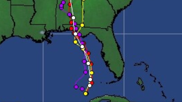
Curent tracking projections.


