


BULLETIN
Hurricane Ida Advisory Number 12…Corrected
NWS National Hurricane Center Miami FL AL092021
400 AM CDT Sun Aug 29 2021
Corrected storm surge heights for Mississippi coast
…DANGEROUS CATEGORY 4 HURRICANE IDA STRENGTHENS SOME MORE…
…LIFE-THREATENING STORM SURGE, POTENTIALLY CATASTROPHIC WIND
DAMAGE, AND FLOODING RAINFALL WILL IMPACT PORTIONS OF THE NORTHERN
GULF COAST BEGINNING LATER THIS MORNING…
SUMMARY OF 400 AM CDT…0900 UTC…INFORMATION
———————————————-
LOCATION…28.0N 89.1W
ABOUT 75 MI…120 KM S OF THE MOUTH OF THE MISSISSIPPI RIVER
ABOUT 145 MI…235 KM SE OF HOUMA LOUISIANA
MAXIMUM SUSTAINED WINDS…140 MPH…220 KM/H
PRESENT MOVEMENT…NW OR 315 DEGREES AT 15 MPH…24 KM/H
MINIMUM CENTRAL PRESSURE…946 MB…27.94 INCHES
WATCHES AND WARNINGS
——————–
CHANGES WITH THIS ADVISORY:
None.
SUMMARY OF WATCHES AND WARNINGS IN EFFECT:
A Storm Surge Warning is in effect for…
* East of Rockefeller Wildlife Refuge Louisiana to the
Alabama/Florida border
* Vermilion Bay, Lake Borgne, Lake Pontchartrain, Lake Maurepas,
and Mobile Bay
A Hurricane Warning is in effect for…
* Intracoastal City Louisiana to the Mouth of the Pearl River
* Lake Pontchartrain, Lake Maurepas, and Metropolitan New Orleans
A Tropical Storm Warning is in effect for…
* Cameron Louisiana to west of Intracoastal City Louisiana
* Mouth of the Pearl River to the Alabama/Florida border
A Storm Surge Warning means there is a danger of life-threatening
inundation, from rising water moving inland from the coastline,
during the next 36 hours in the indicated locations. For a depiction
of areas at risk, please see the National Weather Service Storm
Surge Watch/Warning Graphic, available at hurricanes.gov. This is a
life-threatening situation. Persons located within these areas
should take all necessary actions to protect life and property from
rising water and the potential for other dangerous conditions.
Promptly follow evacuation and other instructions from local
officials.
A Hurricane Warning means that hurricane conditions are expected
somewhere within the warning area within the next 6 to 12 hours.
Preparations to protect life and property should be rushed to
completion.
A Tropical Storm Warning means that tropical storm conditions are
expected somewhere within the warning area, in this case within the
next 12 to 24 hours.
For storm information specific to your area, including possible
inland watches and warnings, please monitor products issued by your
local National Weather Service forecast office.
DISCUSSION AND OUTLOOK
———————-
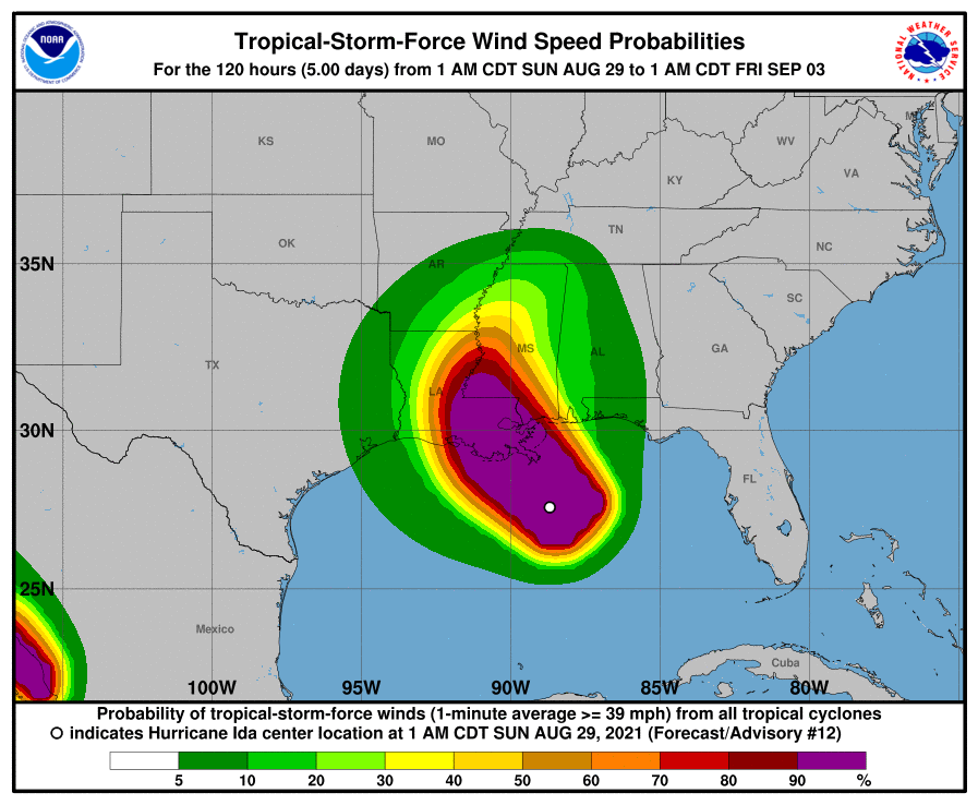
At 400 AM CDT (0900 UTC), the center of Hurricane Ida was located
near latitude 28.0 North, longitude 89.1 West. Ida is moving toward
the northwest near 15 mph (24 km/h), and this general motion should
continue through tonight and early Monday, followed by a slower
northward motion on Monday afternoon. A northeastward turn is
forecast by Monday night. On the forecast track, the center of Ida
will continue moving across the north-central Gulf of Mexico this
morning, and make landfall along the coast of southeastern Louisiana
within the hurricane warning area this afternoon or evening. Ida is
then forecast to move well inland over portions of Louisiana and
western Mississippi on Monday and Monday night.
Satellite and Doppler radar data indicate that maximum sustained
winds have increased to near 140 mph (220 km/h) with higher gusts.
Ida is a category 4 hurricane on the Saffir-Simpson Hurricane Wind
Scale. Some additional strengthening is forecast, and Ida is
expected to be an extremely dangerous major hurricane when it makes
landfall along the Louisiana coast this afternoon. Rapid weakening
is expected after landfall.
Hurricane-force winds extend outward up to 40 miles (65 km) from the
center and tropical-storm-force winds extend outward up to 140 miles
(220 km).
The estimated minimum central pressure is 946 mb (27.94 inches).
HAZARDS AFFECTING LAND
———————-
Key messages for Ida can be found in the Tropical Cyclone
Discussion under AWIPS header MIATCDAT4, WMO header WTNT44 KNHC,
and on the web at hurricanes.gov/graphics_at4.shtml?key_messages.
STORM SURGE: The combination of a dangerous storm surge and the
tide will cause normally dry areas near the coast to be flooded by
rising waters moving inland from the shoreline. The water could
reach the following heights above ground somewhere in the indicated
areas if the peak surge occurs at the time of high tide…
Port Fourchon, LA to Mouth of the Mississippi River…12-16 ft
Morgan City, LA to Port Fourchon, LA …8-12 ft
Mouth of the Mississippi River to Bay St. Louis, MS including Lake
Borgne…8-12 ft
Burns Point, LA to Morgan City, LA…6-9 ft
Bay St. Louis, MS to Ocean Springs, MS…6-9 ft
Lake Pontchartrain…5-8 ft
Ocean Springs, MS to MS/AL border…4-7 ft
Intracoastal City, LA to Burns Point, LA including Vermilion
Bay…4-6 ft
Lake Maurepas…4-6 ft
Pecan Island, LA to Intracoastal City, LA…2-4 ft
MS/AL border to AL/FL border including Mobile Bay…3-5 ft
Sabine Pass to Pecan Island, LA…1-3 ft
AL/FL border to Okaloosa/Walton County Line including Pensacola
Bay…1-3 ft
Overtopping of local levees outside of the Hurricane and Storm
Damage Risk Reduction System is possible where local inundation
values may be higher than those shown above.
The deepest water will occur along the immediate coast near and to
the east of the landfall location, where the surge will be
accompanied by large and dangerous waves. Surge-related flooding
depends on the relative timing of the surge and the tidal cycle, and
can vary greatly over short distances. For information specific to
your area, please see products issued by your local National Weather
Service forecast office.
WIND: Hurricane conditions are expected in the Hurricane Warning
area along the Louisiana coast beginning by later this morning with
tropical storm conditions expected to begin by early this morning.
These conditions will spread inland over portions of Louisiana and
Mississippi tonight and Monday.
RAINFALL: Heavy rainfall from Ida will begin to impact the
southeast Louisiana coast this morning, spreading northeast into the
Lower Mississippi Valley later today into Monday. Total rainfall
accumulations of 10 to 18 inches with isolated maximum amounts of
24 inches are possible across southeast Louisiana into far southern
Mississippi through Monday. This is likely to result in
life-threatening flash and urban flooding and significant riverine
flooding impacts.
Ida is forecast to turn to the northeast early Monday and track
across the Middle Tennessee Valley and Ohio Valley through
Wednesday, producing the following rainfall totals:
Coastal Alabama to the far western Florida panhandle: 5 to 10 inches
with isolated maximum amounts of 15 inches, today through Tuesday
morning.
Central Mississippi: 4 to 8 inches with isolated maximum amounts of
12 inches, tonight through Monday night.
Middle Tennessee Valley to the Ohio Valley: 3 to 6 inches with
isolated higher amounts, Tuesday into Wednesday.
These rainfall totals will result in considerable flash and riverine
flooding.
TORNADOES: Tornadoes will be possible today into Monday from
southeast Louisiana across southeast Mississippi and southwest
Alabama to the western Florida Panhandle.
SURF: Swells are beginning to reach the northern Gulf coast and
will continue to affect that area through Monday. These swells are
likely to cause life-threatening surf and rip current conditions.
Please consult products from your local weather office.
