


Local weather for today Friday , June 18. This report is updated during the day.
BULLETIN
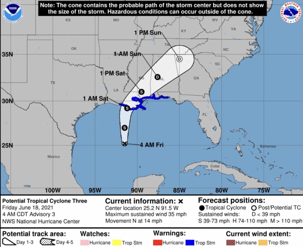
Potential Tropical Cyclone Three Advisory Number 3…Corrected
NWS National Hurricane Center Miami FL AL032021
400 AM CDT Fri Jun 18 2021
Corrected to add states to storm surge communication points
…POTENTIAL TROPICAL CYCLONE THREE EXPECTED TO BRING HEAVY
RAINFALL AND FLOODING TO THE NORTHERN GULF COAST STARTING LATER
TODAY…
SUMMARY OF 400 AM CDT…0900 UTC…INFORMATION
———————————————-
LOCATION…25.2N 91.5W
ABOUT 310 MI…500 KM S OF MORGAN CITY LOUISIANA
ABOUT 435 MI…695 KM SSW OF MOBILE ALABAMA
MAXIMUM SUSTAINED WINDS…35 MPH…55 KM/H
PRESENT MOVEMENT…N OR 360 DEGREES AT 14 MPH…22 KM/H
MINIMUM CENTRAL PRESSURE…1007 MB…29.74 INCHES
WATCHES AND WARNINGS
——————–
CHANGES WITH THIS ADVISORY:
The Tropical Storm Warning has been extended eastward for the
Florida Panhandle from the Alabama/Florida border to the
Okaloosa/Walton County line.
SUMMARY OF WATCHES AND WARNINGS IN EFFECT:
A Tropical Storm Warning is in effect for…
* Intracoastal City Louisiana to the Okaloosa/Walton County line.
* Lake Pontchartrain, Lake Maurepas, and Metropolitan New Orleans
A Tropical Storm Warning means that tropical storm conditions are
expected somewhere within the warning area, in this case within 12
to 24 hours.
Interests elsewhere along the northern Gulf Coast should monitor
the progress of this system.
For storm information specific to your area, including possible
inland watches and warnings, please monitor products issued by your
local National Weather Service forecast office.
DISCUSSION AND OUTLOOK
———————-
At 400 AM CDT (0900 UTC), the poorly defined disturbance was
centered near latitude 25.2 North, longitude 91.5 West. The system
is moving toward the north near 14 mph (22 km/h), and this
general motion is expected for the next day or so. On the forecast
track, the system will approach the north-central Gulf Coast
tonight or early Saturday. A slow northeastward motion across the
southeastern United States is likely after landfall through the
weekend.
Maximum sustained winds are near 35 mph (55 km/h) with higher gusts.
Some strengthening is forecast, and a subtropical or tropical storm
is likely to form over the west-central or northwestern Gulf of
Mexico later today.
* Formation chance through 48 hours…high…90 percent.
* Formation chance through 5 days…high…90 percent.
The estimated minimum central pressure is 1007 mb (29.74 inches),
based on observations from NOAA buoy 42001.
HAZARDS AFFECTING LAND
———————-
Key messages for Potential Tropical Cyclone Three can be found in
the Tropical Cyclone Discussion under AWIPS header MIATCDAT3,
WMO header WTNT43 KNHC, and on the web at
www.huricanes.gov/graphics_at3.shtml?key_messages.
RAINFALL: Rainfall totals of 4 to 8 inches with isolated maximum
amounts of 12 inches are expected across portions of the Central
Gulf Coast beginning today. Considerable flash, urban and small
stream flooding impacts as well as new and renewed minor to isolated
moderate river flooding are likely.
As the system continues to lift northeast through the weekend,
anticipate heavy rain to expand across southeastern Mississippi,
southern and central Alabama, and central Georgia resulting in
rainfall totals of 3 to 5 inches with isolated maximum amounts of 7
inches. Flash, urban, small stream and isolated minor river flooding
impacts are possible.
The potential tropical cyclone is expected to produce total
rainfall of 3 to 6 inches with isolated amounts of 8 inches across
the Yucatan Peninsula of Mexico.
STORM SURGE: The combination of storm surge and the tide will
cause normally dry areas near the coast to be flooded by rising
waters moving inland from the shoreline. The water could reach the
following heights above ground somewhere in the indicated areas if
the peak surge occurs at the time of high tide…
Intracoastal City, LA to Okaloosa/Walton County Line, FL…2-3 ft
Vermilion Bay, Lake Borgne and Mobile Bay …2-3 ft
Lake Pontchartrain and Lake Maurepas…1-2 ft
Okaloosa/Walton County Line, FL to Panama City, FL… 1-2 ft
Cameron, LA to Intracoastal City, LA…1-2 ft
Surge-related flooding depends on the relative timing of the surge
and the tidal cycle, and can vary greatly over short distances. For
information specific to your area, please see products issued by
your local National Weather Service forecast office.
WIND: Tropical storm conditions are expected to first reach the
coast within the warning area later today, making outside
preparations difficult or dangerous.
TORNADOES: The threat for a tornado or two will begin this afternoon
across coastal Louisiana, then spread overnight into Saturday across
southern portions of Louisiana, Mississippi, and Alabama, to the
western Florida Panhandle.
LOCAL WEATHER
Today our temperatures will range from a low of 74° to a high of 84°. Sunrise is 5:45 AM and Sunset 7:51 PM . Night. There is a 90% chance of rain in the morning , 100% chance of rain in the afternoon and 90% chance of rain during the evening.
Winds will range from 5 to 17 mph coming from the SE . Humidity is at 90%. Dew point is at 70%.
UV index is 0.
At 8 PM the current temperature for our area is 74°. Currently the wind is coming from the SE at 13 mph
Pollen count is 4.1 Medium

