


Local weather for today Friday , June 18. This report is updated during the day.
BULLETIN
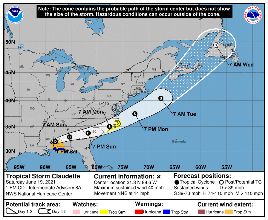
Tropical Depression Claudette Intermediate Advisory Number 9A
NWS National Hurricane Center Miami FL AL032021
700 PM CDT Sat Jun 19 2021
…CENTER OF CLAUDETTE NOW MOVING INTO WESTERN ALABAMA…
…HEAVY RAINS AND GUSTY WINDS CONTINUE ACROSS PORTIONS OF THE
SOUTHEAST U.S…
SUMMARY OF 700 PM CDT…0000 UTC…INFORMATION
———————————————-
LOCATION…32.4N 87.7W
ABOUT 75 MI…120 KM W OF MONTGOMERY ALABAMA
ABOUT 125 MI…200 KM NNE OF MOBILE ALABAMA
MAXIMUM SUSTAINED WINDS…35 MPH…55 KM/H
PRESENT MOVEMENT…NE OR 40 DEGREES AT 15 MPH…24 KM/H
MINIMUM CENTRAL PRESSURE…1005 MB…29.68 INCHES
WATCHES AND WARNINGS
——————–
CHANGES WITH THIS ADVISORY:
None.
SUMMARY OF WATCHES AND WARNINGS IN EFFECT:
A Tropical Storm Watch is in effect for…
* Cape Fear to Duck, North Carolina
* Pamlico and Albemarle Sounds
A Tropical Storm Watch means that tropical storm conditions are
possible within the watch area, in this case within the next 36 to
48 hours.
Interests elsewhere across the southeast U.S. should monitor the
progress of this system.
For storm information specific to your area, including possible
inland watches and warnings, please monitor products issued by your
local National Weather Service forecast office.
DISCUSSION AND OUTLOOK
———————-
At 700 PM CDT (0000 UTC), the center of Tropical Depression
Claudette was located near latitude 32.4 North, longitude 87.7 West.
The depression is moving toward the northeast near 15 mph (24 km/h).
A turn toward the east-northeast is expected tonight and Sunday.
On the forecast track, the system should move farther inland across
portions of the southeast U.S. through Sunday night, and over the
western Atlantic Ocean on Monday.
Maximum sustained winds are near 35 mph (55 km/h) with higher gusts.
These winds are occurring mainly over water well to the south of
the center. Claudette is expected to weaken a little tonight,
however, it is forecast to become a tropical storm again when it
moves across the Carolinas Sunday night or early Monday.
The estimated minimum central pressure based on surface
observations is 1005 mb (29.68 inches).
HAZARDS AFFECTING LAND
———————-
Key messages for Claudette can be found in the Tropical Cyclone
Discussion under AWIPS header MIATCDAT3, WMO header WTNT43 KNHC,
and on the web at
www.hurricanes.gov/graphics_at3.shtml?key_messages.
RAINFALL: Claudette is expected to produce additional rainfall
totals of 3 to 6 inches with isolated maximum amounts of 8 inches
across eastern Alabama, northern Georgia, the Florida Panhandle, and
South and North Carolina. Flash, urban and small stream flooding
impacts as well as new and renewed minor to isolated moderate river
flooding are likely across these areas.
The storm total rainfall is expected to be 5 to 10 inches with
isolated 15 inch totals in southeast Louisiana, southern
Mississippi, southern Alabama, and the western Florida panhandle.
STORM SURGE: The combination of storm surge and the tide will
cause normally dry areas near the coast to be flooded by rising
waters moving inland from the shoreline. The water could reach the
following heights above ground somewhere in the indicated areas if
the peak surge occurs at the time of high tide…
Cape Lookout, NC to NC/VA Border…1-3 ft
Surge-related flooding depends on the relative timing of the surge
and the tidal cycle, and can vary greatly over short distances. For
information specific to your area, please see products issued by
your local National Weather Service forecast office.
WIND: Tropical storm conditions are possible in the watch area
Sunday night and Monday.
TORNADOES: A few tornadoes are possible this evening and tonight
across southeast Alabama, the western Florida Panhandle, and
southwest Georgia.
LOCAL WEATHER
Today our temperatures will range from a low of 77° to a high of 82°. Sunrise is 5:45 AM and Sunset 7:52 PM . Night. There is a 0% chance of rain in the morning , 0% chance of rain in the afternoon and 60% chance of rain during the evening.
Winds will range from 9 to 18 mph coming from the SW . Humidity is at 82%. Dew point is at 75%.
UV index is 0.
At 9 PM the current temperature for our area is 81°. Currently the wind is coming from the SW at 16 mph
Pollen count is 1.1 Low

