BULLETIN
Tropical Depression Ten Advisory Number 1
NWS National Hurricane Center Miami FL AL102023
400 PM CDT Sat Aug 26 2023
…TROPICAL DEPRESSION FORMS NEAR THE YUCATAN CHANNEL…
SUMMARY OF 400 PM CDT…2100 UTC…INFORMATION
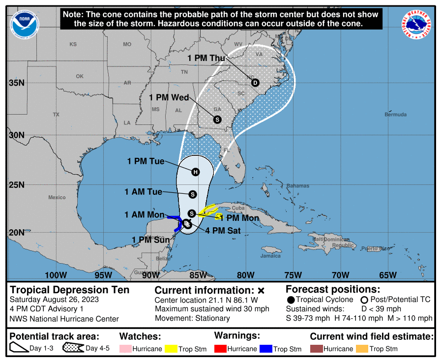
LOCATION…21.1N 86.1W
ABOUT 65 MI…105 KM NE OF COZUMEL MEXICO
MAXIMUM SUSTAINED WINDS…30 MPH…45 KM/H
PRESENT MOVEMENT…STATIONARY
MINIMUM CENTRAL PRESSURE…1006 MB…29.71 INCHES
WATCHES AND WARNINGS
——————–
The government of Mexico has issued a Tropical Storm Warning for
the Yucatan Peninsula of Mexico from Tulum to Rio Lagartos,
including Cozumel.
The government of Cuba has issued a Tropical Storm Watch for
extreme western Cuba for the provinces of Pinar Del Rio and the
Isle of Youth.
SUMMARY OF WATCHES AND WARNINGS IN EFFECT:
A Tropical Storm Warning is in effect for…
* Yucatan Peninsula from Tulum to Rio Lagartos, including Cozumel
A Tropical Storm Watch is in effect for…
* Pinar del Rio and the Isle of Youth
A Tropical Storm Warning means that tropical storm conditions are
expected somewhere within the warning area within 36 hours.
A Tropical Storm Watch means that tropical storm conditions are
possible within the watch area, generally within 48 hours.
For storm information specific to your area, please monitor products
issued by your national meteorological service.
DISCUSSION AND OUTLOOK
———————-
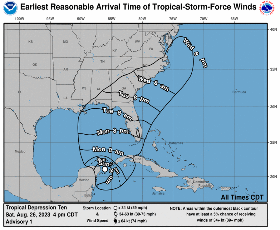
At 400 PM CDT (2100 UTC), the center of Tropical Depression Ten was
located near latitude 21.1 North, longitude 86.2 West. The
depression is nearly stationary, and little overall movement is
expected through Sunday. A slow, generally northward, motion is
expected to begin on Monday. On the forecast track, the center
will move into the southeastern Gulf of Mexico by Monday.
Maximum sustained winds are near 30 mph (45 km/h) with higher gusts.
Gradual strengthening is forecast during the next 48 hours, and the
system is likely to become a tropical storm on Sunday.
The estimated minimum central pressure is 1006 mb (29.71 inches).
HAZARDS AFFECTING LAND
———————-
Key messages for Tropical Depression Ten can be found in the
Tropical Cyclone Discussion under AWIPS header MIATCDAT5 and WMO
header WTNT45 KNHC.
RAINFALL: Tropical Depression Ten is expected to produce rainfall
amounts of 3 to 6 inches, with isolated higher amounts of 10 inches,
across portions of the eastern Yucatan Peninsula. Across western
Cuba, rainfall amounts of 4 to 8 inches, with isolated maximum
amounts of 12 inches, are expected. This rainfall may lead to flash
and urban flooding, and landslides across western Cuba.
Heavy rainfall is also likely to impact portions of the Gulf Coast
and portions of the Southeast by mid- to late next week.
WIND: Tropical storm conditions are expected to begin over portions
of the warning area over the Yucatan Peninsula on Sunday. Tropical
storm conditions are possible within the watch area over western
Cuba beginning on Sunday.
STORM SURGE: Minor coastal flooding is expected within the Tropical
Storm Warning area over the Yucatan Peninsula in areas of onshore
winds.