Hurricane Elsa Advisory Number 14
NWS National Hurricane Center Miami FL AL052021
500 PM EDT Sat Jul 03 2021
…CENTER OF ELSA CLOSE TO THE SOUTHWESTERN PENINSULA OF HAITI…
…NEW TROPICAL STORM WATCHES AND WARNINGS IN CUBA AND THE FLORIDA
KEYS…
SUMMARY OF 500 PM EDT…2100 UTC…INFORMATION
———————————————-
LOCATION…17.5N 73.9W
ABOUT 130 MI…210 KM SW OF PORT AU PRINCE HAITI
ABOUT 195 MI…310 KM E OF KINGSTON JAMAICA
MAXIMUM SUSTAINED WINDS…70 MPH…110 KM/H
PRESENT MOVEMENT…WNW OR 290 DEGREES AT 28 MPH…44 KM/H
MINIMUM CENTRAL PRESSURE…1000 MB…29.53 INCHES
WATCHES AND WARNINGS
——————–
CHANGES WITH THIS ADVISORY:
A Tropical Storm Watch is now in effect for the Florida Keys from
Craig Key westward to the Dry Tortugas.
The Government of Cuba has issued a Tropical Storm Warning for the
provinces of Ciego de Avila, Sancti Spiritus, Villa Clara, and
Cienfuegos, and a Tropical Storm Watch for the provinces of
Mayabeque and Havana.
SUMMARY OF WATCHES AND WARNINGS IN EFFECT:
A Hurricane Warning is in effect for…
* Southern portion of Haiti from Port Au Prince to the southern
border with the Dominican Republic.
A Tropical Storm Warning is in effect for…
* The coast of Haiti north of Port Au Prince
* Southern coast of Dominican Republic from Punta Palenque to the
border with Haiti
* The Cuban provinces of Camaguey, Granma, Guantanamo, Holguin,
Las Tunas, Santiago de Cuba, Ciego de Avila, Sancti Spiritus, Villa
Clara, and Cienfuegos
* Jamaica
A Hurricane Watch is in effect for…
* The Cuban provinces of Camaguey, Granma, Guantanamo, Holguin,
Las Tunas, and Santiago de Cuba
A Tropical Storm Watch is in effect for…
* South coast of the Dominican Republic east of Punta Palenque to
Cabo Engano
* Cayman Brac and Little Cayman
* The Cuban provinces of Matanzas, Mayabeque, and Havana
* The Florida Keys from Craig Key westward to the Dry Tortugas
A Hurricane Warning means that hurricane conditions are expected
somewhere within the warning area. Preparations to protect life
and property should be rushed to completion.
A Tropical Storm Warning means that tropical storm conditions are
expected somewhere within the warning area.
A Hurricane Watch means that hurricane conditions are possible
within the watch area. A watch is typically issued 48 hours
before the anticipated first occurrence of tropical-storm-force
winds, conditions that make outside preparations difficult or
dangerous.
A Tropical Storm Watch means that tropical storm conditions are
possible within the watch area.
Interests elsewhere in the Cuba, the Cayman Islands, the Florida
peninsula, and the Florida Keys should monitor the progress of Elsa.
Additional watches and warnings will likely be required tonight or
on Sunday.
For storm information specific to your area in the United States,
including possible inland watches and warnings, please monitor
products issued by your local National Weather Service forecast
office. For storm information specific to your area outside of the
United States, please monitor products issued by your national
meteorological service.
DISCUSSION AND OUTLOOK
———————-
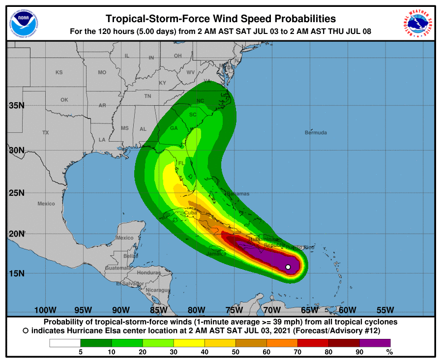
At 500 PM EDT (2100 UTC), the center of Tropical Storm Elsa was
located near latitude 17.5 North, longitude 73.9 West. Elsa is
moving toward the west-northwest near 28 mph (44 km/h). A decrease
in forward speed is expected tonight and on Sunday, followed by a
turn toward the northwest Sunday night or Monday. On the forecast
track, Elsa will move near the southwestern peninsula of Haiti over
the next few hours, and then move near Jamaica and portions of
eastern Cuba on Sunday. By Monday, Elsa is expected to move across
central and western Cuba and head toward the Florida Straits. Elsa
is then forecast to move move near or over portions of the west
coast of Florida on Tuesday.
Maximum sustained winds are near 70 mph (110 km/h) with higher
gusts. Little change in strength is forecast through Sunday, but
gradual weakening is forecast on Sunday night and Monday when Elsa
is expected to be near or over Cuba.
Tropical-storm-force winds extend outward up to 125 miles (205 km)
mainly to the north of the center.
The latest minimum central pressure reported by a NOAA Hurricane
Hunter aircraft is 1000 mb (29.53 inches).
HAZARDS AFFECTING LAND
———————-
Key messages for Elsa can be found in the Tropical Cyclone
Discussion under AWIPS header MIATCDAT5, WMO header WTNT45 KNHC and
on the web at
www.hurricanes.gov/graphics_at5.shtml?key_messages.
WIND: Hurricane conditions are still possible in the hurricane
warning area in Haiti for a few more hours. Hurricane conditions
are possible in eastern Cuba on Sunday. Tropical Storm conditions
are possible for a few more hours over portions of the Dominican
Republic, and are expected on Jamaica and over eastern and central
Cuba on Sunday. Tropical storm conditions are possible in the
watch area in the Cayman Islands Sunday and Sunday night and in
western Cuba and the Florida Keys Sunday night and Monday.
STORM SURGE: A storm surge will raise water levels above normal tide
levels by as much as the following amounts in areas of onshore flow
within the hurricane watch and warning areas…
Southern coast of Cuba…3 to 5 feet
Southern coast of Hispaniola…2 to 4 feet
The combination of a storm surge and the tide will cause normally
dry areas near the coast to be flooded by rising waters moving
inland from the shoreline. The water could reach the following
heights above ground somewhere in the indicated areas if the peak
surge occurs at the time of high tide…
Craig Key, FL to Dry Tortugas…1-2 ft
Surge-related flooding depends on the relative timing of the surge
and the tidal cycle, and can vary greatly over short distances. For
information specific to your area, please see products issued by
your local National Weather Service forecast office.
RAINFALL: Across portions of southern Hispaniola and Jamaica,
rainfall of 4 to 8 inches with isolated maximum amounts of 15 inches
is expected today into Sunday. This rain may lead to scattered flash
flooding and mudslides, some of which may be significant in nature.
Across portions of Cuba Sunday into Monday, rainfall of 5 to 10
inches with isolated maximum amounts of 15 inches is expected. This
will result in significant flash flooding and mudslides.
Across the Cayman Islands Sunday into Monday, rainfall of 3 to 6
inches is expected. This rain may lead to scattered flash flooding.
Rainfall from Elsa is likely to impact portions of the Florida Keys
and Florida Peninsula early next week. Amounts of 2 to 4 inches with
localized maximum amounts up to 6 inches will be possible, which may
result in isolated flash, urban, and minor river flooding.
SURF: Swells generated by Elsa will spread westward across the
Caribbean Sea through the weekend. These swells are likely to cause
life-threatening surf and rip current conditions. Please consult
products from your local weather office.