

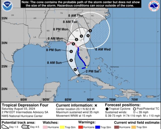
Tropical Depression Four Intermediate Advisory Number 5ANWS National Hurricane Center Miami FL AL042024 200 PM EDT Sat Aug 03 2024
DEPRESSION STARTING TO MOVE INTO THE SOUTHEASTERN GULF OF
MEXICO…
…TROPICAL STORM WARNING ISSUED FOR PORTIONS OF THE FLORIDA KEYS…
SUMMARY OF 200 PM EDT…1800 UTC…INFORMATION
———————————————-
LOCATION…23.1N 82.6W
ABOUT 15 MI…25 KM WNW OF HAVANA CUBA
ABOUT 115 MI…185 KM SSW OF KEY WEST FLORIDA
MAXIMUM SUSTAINED WINDS…35 MPH…55 KM/H
PRESENT MOVEMENT…WNW OR 300 DEGREES AT 15 MPH…24 KM/H
MINIMUM CENTRAL PRESSURE…1009 MB…29.80 INCHES
WATCHES AND WARNINGS
——————–
CHANGES WITH THIS ADVISORY:
A Tropical Storm Warning is now in effect for the Florida Keys from
the Seven Mile Bridge westward.
SUMMARY OF WATCHES AND WARNINGS IN EFFECT:
A Hurricane Watch is in effect for…
* Indian Pass to Yankeetown
A Tropical Storm Warning is in effect for…
* The Florida Keys west of the Seven Mile Bridge including the Dry
Tortugas
* West coast of the Florida peninsula from south of Yankeetown
to East Cape Sable
A Tropical Storm Watch is in effect for…
* The Florida Keys north of the Seven Mile Bridge to the Channel 5
Bridge
A Storm Surge Warning is in effect for…
* Aripeka northward to the Aucilla River
A Storm Surge Watch is in effect for…
* Bonita Beach northward to Aripeka, including Tampa Bay
and Charlotte Harbor
* West of the Aucilla River to Indian Pass
A Tropical Storm Warning means that tropical storm conditions are
expected somewhere within the warning area within 36 hours.
A Hurricane Watch means that hurricane conditions are possible
within the watch area. A watch is typically issued 48 hours before
the anticipated first occurrence of tropical-storm-force winds,
conditions that make outside preparations difficult or dangerous.
A Tropical Storm Watch means that tropical storm conditions are
possible within the watch area, generally within 48 hours.
A Storm Surge Warning means there is a danger of life-threatening
inundation, from rising water moving inland from the coastline,
during the next 36 hours in the indicated locations. For a
depiction of areas at risk, please see the National Weather
Service Storm Surge Watch/Warning Graphic, available at
This is a life-threatening situation. Persons located within these
areas should take all necessary actions to protect life and property
from rising water and the potential for other dangerous conditions.
Promptly follow evacuation and other instructions from local
officials.
A Storm Surge Watch means there is a possibility of life-
threatening inundation, from rising water moving inland from the
coastline, in the indicated locations during the next 48 hours.
For a depiction of areas at risk, please see the National Weather
Service Storm Surge Watch/Warning Graphic, available at
Interests elsewhere in Florida and the southeastern coast of the
United States should monitor the progress of this system. Additional
warnings and watches will likely be required for a portion of this
area later today.
For storm information specific to your area, including possible
inland watches and warnings, please monitor products issued by your
local National Weather Service forecast office.
DISCUSSION AND OUTLOOK
———————-
At 200 PM EDT (1800 UTC), the center of Tropical Depression Four was
located near latitude 23.1 North, longitude 82.6 West. The
depression is moving toward the west-northwest near 15 mph (24
km/h). A turn toward the northwest is forecast this afternoon,
followed by a northward motion on Sunday and then a slower
northeastward motion Sunday night and Monday. On the forecast track,
the center of the depression will move across western Cuba this
morning, and then move over the eastern Gulf of Mexico later today
and Sunday, reaching the Florida Gulf coast late Sunday or Monday.
Recent satellite wind data and surface observations from the
Florida Keys indicate that maximum sustained winds are near 35 mph
(55 km/h) with higher gusts. Slow strengthening is expected this
afternoon and tonight, and the depression is expected to become a
tropical storm by tonight. A faster rate of strengthening is
expected Sunday through Monday, and the system could be near
hurricane strength when it reaches the Florida Gulf coast.
The estimated minimum central pressure based on surface
observations from Cuba and the Florida Keys is 1009 mb (29.80
inches).
HAZARDS AFFECTING LAND
———————-
Key messages for the depression can be found in the Tropical Cyclone
Discussion under AWIPS header MIATCDAT4 and WMO header WTNT44 KNHC.
WIND: Hurricane conditions are possible in the hurricane watch area
by Sunday night, with tropical storm conditions possible earlier on
Sunday. Tropical storm conditions are expected to spread northward
over the warning areas beginning later today and continuing through
Sunday. Tropical storm conditions are possible in the watch area in
the Florida Keys later today or tonight, and in the Florida
Panhandle by late Sunday. Wind gusts to tropical storm force are
currently occurring over the Florida Keys.
STORM SURGE: The combination of storm surge and tide will cause
normally dry areas near the coast to be flooded by rising waters
moving inland from the shoreline. The water could reach the
following heights above ground somewhere in the indicated areas if
the peak surge occurs at the time of high tide…
Aripeka, FL to Aucilla River, FL…3-5 ft
Aucilla River, FL to Indian Pass, FL…2-4 ft
Bonita Beach, FL to Aripeka, FL…2-4 ft
Tampa Bay…2-4 ft
Charlotte Harbor…2-4 ft
For a complete depiction of areas at risk of storm surge inundation,
please see the National Weather Service Peak Storm Surge Graphic,
available at hurricanes.gov/graphics_at4.shtml?peakSurge.
RAINFALL: Tropical Depression Four is expected to produce rainfall
totals of 5 to 10 inches, with maximum rainfall totals up to 15
inches, across portions of Florida and along the Southeast U.S.
coast this weekend through Thursday morning. This rainfall will
likely result in areas of locally considerable flash and urban
flooding, with river flooding expected.
For Cuba, rainfall amounts of 1 to 2 inches, with localized higher
amounts, will be possible through today. This may result in isolated
to scattered areas of flooding.
For a complete depiction of forecast rainfall and flash flooding
associated with Tropical Depression Four, please see the National
Weather Service Storm Total Rainfall Graphic, available at
hurricanes.gov/graphics_at4.shtml?rainqpf
TORNADOES: A tornado or two is possible across the Florida Keys and
the western Florida Peninsula tonight through Sunday morning.
SURF: Swells generated by the depression are expected to affect
much of the Gulf coast of Florida tonight through Monday and along
the Southeast U.S. coast early next week. These swells are likely
to cause life-threatening surf and rip current conditions. Please
consult products from your local weather office.

