

Potential Tropical Cyclone Four Advisory Number 1NWS National Hurricane Center Miami FL AL042024
1100 AM EDT Fri Aug 02 2024
…DISTURBANCE LOCATED OVER EASTERN CUBA…
…TROPICAL STORM WARNINGS AND WATCHES ISSUED FOR PORTIONS OF
FLORIDA…
SUMMARY OF 1100 AM EDT…1500 UTC…INFORMATION
———————————————–
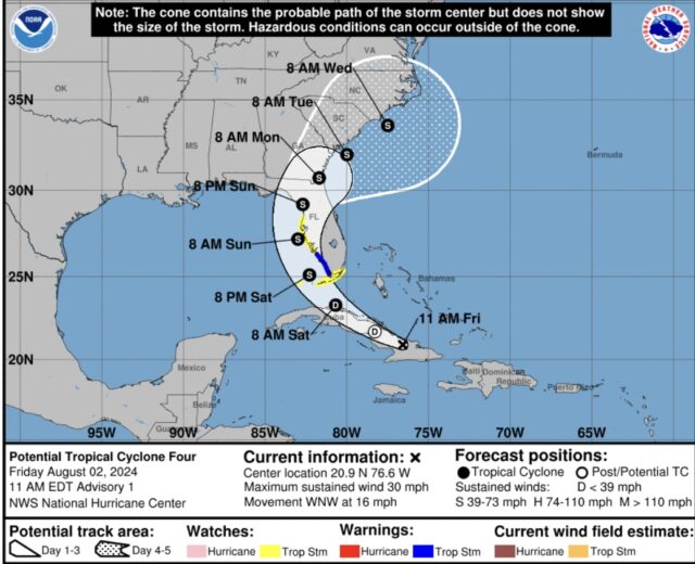
LOCATION…20.9N 76.6W
ABOUT 90 MI…145 KM ESE OF CAMAGUEY CUBA
ABOUT 420 MI…675 KM SE OF KEY WEST FLORIDA
MAXIMUM SUSTAINED WINDS…30 MPH…45 KM/H
PRESENT MOVEMENT…WNW OR 290 DEGREES AT 16 MPH…26 KM/H
MINIMUM CENTRAL PRESSURE…1012 MB…29.89 INCHES
WATCHES AND WARNINGS
——————–
CHANGES WITH THIS ADVISORY:
A Tropical Storm Warning is now in effect for the southwest coast
of the Florida peninsula from East Cape Sable to Bonita Beach.
A Tropical Storm Watch is now in effect for the Florida Keys south
of the Card Sound Bridge including the Dry Tortugas, the southern
coast of the Florida peninsula east of East Cape Sable to the Card
Sound bridge, and for the west coast of the Florida peninsula north
of Bonita Beach to Aripeka.
SUMMARY OF WATCHES AND WARNINGS IN EFFECT:
A Tropical Storm Warning is in effect for…
* Southwest coast of the Florida peninsula from East Cape Sable to
Bonita Beach
A Tropical Storm Watch is in effect for…
* The Florida Keys south of the Card Sound Bridge including the Dry
Tortugas
* The southern coast of the Florida peninsula east of East Cape
Sable to the Card Sound Bridge
* The west coast of the Florida peninsula north of Bonita Beach to
Aripeka
A Tropical Storm Warning means that tropical storm conditions are
expected somewhere within the warning area within 36 hours.
A Tropical Storm Watch means that tropical storm conditions are
possible within the watch area, generally within 48 hours.
Interests elsewhere in the Florida Peninsula should monitor the
progress of this system. Additional warnings and watches may be
required for a portion of this area tonight and Saturday.
For storm information specific to your area, including possible
inland watches and warnings, please monitor products issued by your
local National Weather Service forecast office.
DISCUSSION AND OUTLOOK
———————-
At 1100 AM EDT (1500 UTC), the disturbance was centered near
latitude 20.9 North, longitude 76.6 West. The system is moving
toward the west-northwest near 16 mph (26 km/h). A turn toward the
northwest at a slower forward speed is expected tonight or Saturday,
followed by a turn toward the north on Sunday. On the forecast
track, the disturbance is expected to move over Cuba today, cross
the Straits of Florida on Saturday, and then move near or over the
west coast of Florida Saturday night through Sunday night.
Maximum sustained winds are near 30 mph (45 km/h) with higher gusts.
The disturbance is expected to develop into a tropical depression on
Saturday as it moves across the Straits of Florida, followed by
intensification into a tropical storm by Saturday night.
* Formation chance through 48 hours…high…70 percent.
* Formation chance through 7 days…high…90 percent.
The estimated minimum central pressure is 1012 mb (29.89 inches).
HAZARDS AFFECTING LAND
———————-
WINDS: Tropical storm conditions are expected in the warning area
late Saturday and Saturday night. Tropical storm conditions are
possible in the watch area in the Florida Keys and the southern
Florida peninsula by Saturday or Saturday night. Tropical storm
conditions are possible in the watch area along the Florida west
coast Saturday night or Sunday.
STORM SURGE: The combination of storm surge and tide will cause
normally dry areas near the coast to be flooded by rising waters
moving inland from the shoreline. The water could reach the
following heights above ground somewhere in the indicated areas if
the peak surge occurs at the time of high tide…
Aripeka, FL to Card Sound Bridge, FL…1-3 ft
Tampa Bay…1-3 ft
Charlotte Harbor…1-3 ft
RAINFALL: Potential Tropical Cyclone Four is expected to produce
rainfall totals of 4 to 8 inches, with maximum rainfall totals up to
12 inches, across portions of Florida and near the Southeast U.S.
coast this weekend through Wednesday morning. This rainfall could
result in areas of flash and urban flooding, with isolated river
flooding possible.
For a complete depiction of forecast rainfall and flash flooding
associated with Potential Tropical Cyclone Four, please see the
National Weather Service Storm Total Rainfall Graphic, available at
hurricanes.gov/graphics_at3.shtml?rainqpf


